What City Planning Is and Why It Starts With a Shared Vision

Somebody isn't sitting around hoping for a hospital to be in the right place, or for streets to be connected in a way that won't cause flooding during heavy rainfall. No, this is a well-thought-out urban planning system, which ensures that everything is coordinated so that land-use, infrastructure, public services, and long-term growth do not work against one another.
A serious planning process always starts from a strategic vision: a broad statement about how the city would want to evolve over the next 10, 20, maybe even 50 years. This vision is operationalized through a master plan - which obviously shows towards the zoning of land, transport, housing, and open spaces.
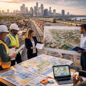
All the pre-planning numbers being crunched, planners first set the problems up on a grid map-finding ways to relieve overpopulation, reduce traffic congestion, avert flooding, and deliver equitable access to schools and healthcare. Then, decisions regarding the most critical problems should be solved with data and by engaging with stakeholders in various ways, seeking input from residents, businesses, and local officials as to where the burden lays and what the most immediate problems are.
How the Planning Process Moves From Research to Policy
Evidence comes first. Before any zoning map gets drawn or housing target gets set, planners spend months gathering data on population growth, employment patterns, flood zones, and infrastructure capacity. This produces a baseline picture of what the city is, not just what officials hope it will become.
Mapping follows. Planners layer constraints like flood plains and heritage sites against opportunities such as underused land or transit corridors. Singapore's 2019 Master Plan used exactly this method to identify sites for 330,000 new homes near existing rail lines.
Public consultation then shapes priorities. When Barcelona redesigned its superblocks, resident feedback directly influenced which streets lost car access. That input gets tested through scenario modeling before anything is committed to paper.
How Plans Become Real Projects and Keep Adapting
Approval of a master plan is not the finish line. It's closer to the starting gun.
Turning a plan into actual streets, housing, parks, and transit requires zoning codes that tell developers what can be built where, capital budgets that fund construction in phases, and permit systems that enforce standards project by project. A city might approve a transit corridor in its strategic vision, then spend three years securing federal funding, coordinating with a transit authority, acquiring land parcels, and issuing construction contracts before a single rail tie goes down.
Monitoring closes the loop. Planners track indicators like housing production rates, commute times, or tree canopy coverage to judge whether goals are being met. When new pressures emerge - a population surge, a flood event, a major employer leaving - plans get revised. Cities that treat planning as a living process adapt. Those that don't tend to find their 20-year vision obsolete within a decade.
Good Planning Turns Growth Into Better Cities
City planning is a conscientious sequence of choices, not a single grand scheme. It starts from a collective understanding of what a community intends to become, and then it moves to genuinely knowing itself through research and stakeholder engagement, leading to real-life actions. At the end of the day, document assignment only hints at what is but one job. It is the constellation of decisions across agencies, budgets, timelines, and communities-coordinated differently as the populace shifts and needs expand-that shape practical and probable lifestyles, robustness, and equity of urban living, or not. Planning is what does not address growth but its outcomes are felt by the people it serves when carried out right.
UMUAHIA URBAN RENEWAL AND BEAUTIFICATION CONTINUES BY ABSG
— New Abia (@GreatAbia) March 24, 2026
The Commissioner of Information, Prince Okey Kanu, has stated that the state government has thought it wise to install speed bumps on some of the newly constructed roads, roadside tree planting, landscaping of designated pic.twitter.com/Wf7orqHXtd
Undoing the damage of sweeping mid-century urban renewal on the near south side really ought to be a goal of this city. And I don't think mega projects are the answer here... https://t.co/m8bWFFA4Dd pic.twitter.com/TYV7dHkDCr
— Midwest Antiquarian (@Eric_Erins) April 2, 2026